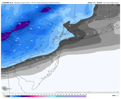
The first signficant snowfall in much of our area will occur on Wednesday as a disturbance passes through our area, causing snow to develop in the morning, gradually changing to rain from late morning and early afternoon near the Central NJ Coast and on Long Island to the eartly evening in Northeastern PA, then ending at night. After this, things are currently looking cooler, but quiet through the rest of the two-week period.
Total possible snowfall accumulation:
Coating to an inch or two possible: Coastal Central NJ and Eastern Long Island
2-4 inches possible: inland Central and Northeastern NJ, NYC, Southeastern NY State, Fairfield County, CT
3-5 inches possible: East Central PA, Northwestern NJ, far Northwestern Orange County, NY
4-7 inches possible: Northeastern PA
Below is the latest European model snow map, courtesy WeatherBell Analtyics. Click on the image to enlarge.


No comments:
Post a Comment
Note: Only a member of this blog may post a comment.