Friday, December 16, 2022

Friday, December 16, 2022 - Daily Weather Discussion


This storm will end this evening, but we already need to keep a close eye on the next one…


This storm developed into a strong Nor’easter that brought heavy rain and snow to parts of our area, with up to 7 inches of snow in Mount Pocono, Monroe County, PA, and 4 inches in High Point, Sussex County, NJ.


Click here for some snowfall totals in our area.


This storm will pull away from our area this evening, and then it will be cold for the foreseeable future.


Two disturbances then approach our area next Wednesday, likely developing into a strong Nor’easter next Thursday that will bring our area a threat for more heavy rain and snow developing Thursday morning and ending Friday morning. Check back for updates…


Follow this blog @TheEdgeWeather on Twitter


Send weather related photos or videos to edgeweather2@gmail.com


Also, you can access this blog at the following web addresses:  edgeweather.com, theedgeweather.com, edgeweather.net, theedgeweather.net, edgeweather.us, theedgeweather.us, edgeweather.org, theedgeweather.org, and theedgeweather.blogspot.com

Friday, December 16, 2022 - Look at the Next 2 Weeks


TODAY – rain ending this evening, highs from the mid 30’s in Northeastern PA to the low 50’s near the NJ Coast and on Long Island


TOMORROW – variably cloudy, lows in the mid 20’s to mid 30’s, highs from the low 30’s in Northeastern PA to the low 40’s in East Central NJ, NYC, and on Long Island


SUNDAY – variably cloudy, lows mainly in the 20’s, highs in the upper 20’s to mid 30’s


MONDAY – variably cloudy, lows in the mid 20’s to low 30’s, highs in the mid 30’s to low 40’s


TUESDAY – variably cloudy, lows in the 20’s, highs in the 30’s


WEDNESDAY – variably cloudy, lows mainly in the 20’s, highs in the 30’s


THURSDAY – chance of rain or snow, lows from the upper teens in Northeastern PA to the mid 30’s along the NJ Coast, highs from the low 30’s in Northeastern PA to the mid 40’s along the NJ Coast and on Long Island


NEXT FRIDAY – chance of rain or snow ending in the morning, then clearing, lows mainly in the 20’s, highs from the low 20’s in Northeastern PA to the mid 30’s on Eastern Long Island


NEXT SATURDAY – variably cloudy, lows mainly in the teens, highs in the 20’s


NEXT SUNDAY – variably cloudy, lows mainly in the teens, highs in the mid 20’s to low 30’s


NEXT MONDAY – variably cloudy, lows in the teens to low 20’s, highs in the mid 20’s to low 30’s


NEXT TUESDAY – variably cloudy, lows in the teens to low 20’s, highs in the mid 20’s to mid 30’s


NEXT WEDNESDAY – variably cloudy, lows in the teens to low 20’s, highs in the upper 20’s to mid 30’s


NEXT THURSDAY – variably cloudy, lows in the upper teens to mid 20’s, highs in the 30’s


Follow this blog @TheEdgeWeather on Twitter


Send weather related photos or videos to edgeweather2@gmail.com


Also, you can access this blog at the following web addresses:  edgeweather.com, theedgeweather.com, edgeweather.net, theedgeweather.net, edgeweather.us, theedgeweather.us, edgeweather.org, theedgeweather.org, and theedgeweather.blogspot.com

Thursday, December 15, 2022

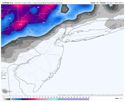
Mid-Morning European Model Snowfall Map...


Below are the latest European and short-range American model snowfall maps, courtesy WeatherBell Analytics. Click on the image to enlarge...


And below is the latest short-range American model snowfall map, courtesy Weather Bell Analytics. Click on the image to enlarge.


Follow this blog @TheEdgeWeather on Twitter


Send weather related photos or videos to edgeweather2@gmail.com


Also, you can access this blog at the following web addresses:  edgeweather.com, theedgeweather.com, edgeweather.net, theedgeweather.net, edgeweather.us, theedgeweather.us, edgeweather.org, theedgeweather.org, and theedgeweather.blogspot.com

Thursday, December 15, 2022 - Daily Weather Discussion


Rain and snow developing this afternoon and evening, bringing significant snow to parts of our area, but the big story for many of us will be the potential for a big pre-Christmas snowstorm next Thursday into Friday...


Rain and snow will develop from late morning into this evening, ending tomorrow evening, bringing parts of our area signficant snow.


It will then get quite cold behing this storm, and then two strong disturbances will approach our area the middle of next week, one in the southern Jet Stream and one in the Northern Jet Stream. It is looking likely at that these two disturbances and jet streams will merge near the Middle Atlantic Coast next Thursday into Friday, causing a strong Nor'easter to develop. This would bring us a chance for a significant pre-Christmas snowstorm next Thursday into Friday. Check back as we get closer in time...


Below is that latest European model snow map for today into tomorrow, courtesy WeatherBell Analytics. Click on the image to enlarge...


Follow this blog @TheEdgeWeather on Twitter


Send weather related photos or videos to edgeweather2@gmail.com


Also, you can access this blog at the following web addresses:  edgeweather.com, theedgeweather.com, edgeweather.net, theedgeweather.net, edgeweather.us, theedgeweather.us, edgeweather.org, theedgeweather.org, and theedgeweather.blogspot.com

Thursday, December 15, 2022 - Look at the Next 2 Weeks


TODAY – rain and snow developing from southwest to northeast from late morning till early evening, highs from the low to mid 30’s in Northeastern PA to the mid 40’s along the coast and on Long Island


Total possible snowfall accumulation:


Trace to an inch:  Western portions of Northwestern NJ, Rockland and Westchester Counties in NY State from south to north, Northern Fairfield County CT from south to north


1-2 inches:  Southern Lehigh and Northampton Counties in PA, Southeastern sections of Northwestern NJ, Putnam and Southeastern Orange Counties in NY State


2-5 inches:  Northern Lehigh and Northern Northampton Counties in PA, the rest of Northwestern NJ (except far NW sections), Central Orange County, NY


4-10 inches:  Northeastern PA, far Northwestern NJ, Western Orange County, NY


TOMORROW – rain and snow ending in the evening from southwest to northeast, lows in the mid 30’s to mid 40’s, but around 50 along the NJ Coast, highs from the mid 30’s in Northeastern PA to the upper 40’s along the coast and on Long Island


SATURDAY – variably cloudy, lows in the mid 20’s to mid 30’s, highs from the low 30’s in Northeastern PA to the mid 40’s in East Central NJ, NYC, and on Long Island


SUNDAY – variably cloudy, lows from the mid teens in Northeastern PA to the upper 20’s along the coast and on Long Island, highs mainly in the low to mid 30’s


MONDAY – variably cloudy, lows mainly in the 20’s, highs in the 30’s


TUESDAY –variably cloudy, lows mainly in the 20’s, highs in the 30’s to low 40’s


WEDNESDAY – variably cloudy, lows mainly in the 20’s, highs in the mid 20’s to mid 30’s


NEXT THURSDAY – snow developing in the late morning, possibly some rain near the coast and on Long Island, lows from the mid teens in Northeastern PA to around 30 along the NJ Coast, highs from the upper 20’s in Northeastern PA to the low to mid 40’s along the NJ Coast


NEXT FRIDAY – snow ending in the late morning and early afternoon from south to north, lows from the upper teens in Northeastern PA to the low 30’s along the coast and on Long Island, highs from the mid 20’s in Northeastern PA to the mid 30’s along the coast and on Long Island


NEXT SATURDAY – variably cloudy, lows in the teens to low 20’s, highs mainly in the 20’s


NEXT SUNDAY – variably cloudy, lows from the upper single digits in Northeastern PA to the upper teens on Long Island, highs mainly in the 20’s


NEXT MONDAY – variably cloudy, lows from the upper single digits in Northeastern PA to the low 20’s on Long Island, highs in the mid 20’s to low 30’s


NEXT TUESDAY – variably cloudy, lows from the low teens in Northeastern PA to the mid 20’s along the coast and on Long Island, highs in the mid 20’s to mid 30’s


NEXT WEDNESDAY – increasing cloudiness, chance of snow developing at night, lows from the mid teens to the mid 20’s, highs in the upper 20’s to mid 30’s


Follow this blog @TheEdgeWeather on Twitter


Send weather related photos or videos to edgeweather2@gmail.com


Also, you can access this blog at the following web addresses:  edgeweather.com, theedgeweather.com, edgeweather.net, theedgeweather.net, edgeweather.us, theedgeweather.us, edgeweather.org, theedgeweather.org, and theedgeweather.blogspot.com

Wednesday, December 14, 2022

Wednesday Afternoon European Model Snow Map for Tomorrow Afternoon into Friday Morning...


Below is the latest snow map from the European model for tomorrow afternoon into Friday morning, courtesy WeatherBell Analytics. Click on the image to enlarge. Keep in mind that the majority of this snow on the barrier between rain and snow will occur at the start of the storm on Thursday afternoon and evening, before changing to rain... 


Follow this blog @TheEdgeWeather on Twitter


Send weather related photos or videos to edgeweather2@gmail.com


Also, you can access this blog at the following web addresses:  edgeweather.com, theedgeweather.com, edgeweather.net, theedgeweather.net, edgeweather.us, theedgeweather.us, edgeweather.org, theedgeweather.org, and theedgeweather.blogspot.com

Wednesday, December 14, 2022 - Daily Weather Discussion


Significant snow tomorrow afternoon into Friday in parts of our area and then we need to watch next Thursday and Friday as well…


There will be significant snow in parts of our area tomorrow into Friday as a strong disturbance passes through our area. Below is the latest snow map from the European model, courtesy WeatherBell Analytics. Click on the image to enlarge.


It will then get quite cold behind this storm.


We will then have to watch for another strong storm next Thursday into Friday.


Follow this blog @TheEdgeWeather on Twitter


Send weather related photos or videos to edgeweather2@gmail.com


Also, you can access this blog at the following web addresses:  edgeweather.com, theedgeweather.com, edgeweather.net, theedgeweather.net, edgeweather.us, theedgeweather.us, edgeweather.org, theedgeweather.org, and theedgeweather.blogspot.com

Wednesday, December 14, 2022 - Look at the Next 2 Weeks


TODAY – variably cloudy, highs in the mid 30’s to low 40’s


TOMORROW – increasing cloudiness, snow developing in the late morning and early afternoon in East Central and Northeastern PA, in the afternoon in Northwestern NJ and Orange County, NY, and in Putnam County, NY in the late afternoon or early evening, and rain or a mixture of rain and snow developing elsewhere, lows in the mid 20’s to mid 30’s, highs in the mid 30’s to mid 40’s


FRIDAY – rain ending in the afternoon, except snow ending in Northeastern PA, Northwestern NJ, and Orange and Putnam Counties in NY, lows in the mid 30’s to mid 30’s, highs from the mid 30’s in Northeastern PA to the low 50’s on Long Island


Total possible snowfall accumulation:


Trace to an in or two from east to west:  western portions of Northeastern NJ, Northwestern Westchester County, NY, Rockland County, NY, Northern Fairfield County, CT


1-4 inches:  East Central PA, Putnam County, NY, most of Northwestern NJ, Eastern Orange County, NY


4-8 inches:  Northeastern PA, far Northwestern NJ, Western Orange County, NY


SATURDAY – variably cloudy, lows in the mid 20’s to mid 30’s, highs in the mid 30’s to mid 40’s


SUNDAY – variably cloudy, lows from the mid to upper teens in Northeastern PA to the low 30’s on Long Island, highs in the 30’s


MONDAY – mostly sunny, lows in the 20’s to low 30’s, highs in the 30’s


TUESDAY – variably cloudy, lows in the upper teens and 20’s, highs in the 30’s


NEXT WEDNESDAY – variably cloudy, lows from the mid teens in Northeastern PA to the upper 20’s along the coast and on Long Island, highs in the mid 20’s to mid 30’s


NEXT THURSDAY – chance of rain or snow, lows from the mid teens in Northeastern PA to the low 30’s along the coast and on Long Island, highs from the low 30’s in Northeastern PA to the mid 40’s in East Central NJ and on Long Island


NEXT FRIDAY – chance of snow or snow showers, lows from the mid to upper teens in Northeastern PA to the low 30’s along the coast and on Long Island, highs from the low 20’s in Northeastern PA to the mid 30’s along the coast and on Long Island


NEXT SATURDAY – mostly sunny, lows from around 10 in Northeastern PA to the mid 20’s on Long Island, highs from the upper teens in Northeastern PA to the upper 20’s along the coast and on Long Island


NEXT SUNDAY – variably cloudy, lows from the mid to upper singles digits in Northeastern PA to the low 20’s on Long Island, highs from the low 20’s in Northeastern PA to the low 30’s in Central NJ, NYC, and on Long island


NEXT MONDAY – variably cloudy, lows from around 10 in Northeastern PA to the mid 20’s along the coast and on Long Island, highs from the mid 20’s in Northeastern PA to the mid 30’s along the coast and on Long Island


NEXT TUESDAY – variably cloudy, lows from the low teens in Northeastern PA to the mid 20’s along the coast and on Long island, highs from the mid to upper 20’s in Northeastern PA to the mid 30’s in Central NJ, NYC, and on Long Island


Follow this blog @TheEdgeWeather on Twitter


Send weather related photos or videos to edgeweather2@gmail.com


Also, you can access this blog at the following web addresses:  edgeweather.com, theedgeweather.com, edgeweather.net, theedgeweather.net, edgeweather.us, theedgeweather.us, edgeweather.org, theedgeweather.org, and theedgeweather.blogspot.com

Tuesday, December 13, 2022

Tuesday, December 13, 2022 - Daily Weather Discussion


A strong storm will bring our area rain and significant snow to parts of our area Thursday afternoon into Friday, and then next week is looking rather wintry in our area heading into Christmas weekend…


Today and tomorrow will be nice with highs in the mid 30’s to low 40’s.


Thursday a strong disturbance will approach our area, bringing rain and snow to our area Thursday afternoon into Friday, with significant snow possible in Northeastern PA, far Northwestern NJ, and Western Orange County, NY.


Below is the latest snow map for Thursday afternoon into Friday, courtesy WeatherBell Analytics. Click on the image to enlarge...


Saturday through next Tuesday, December 20th, will then be nice.


Next Wednesday through around midday Friday we will need to watch a couple of potential disturbances closely to see how and where they develop, as they could bring a chance of snow to our area. 


Christmas Eve and Christmas Day should then be nice, with a chance of snow the morning after Christmas. 


Follow this blog @TheEdgeWeather on Twitter


Send weather related photos or videos to edgeweather2@gmail.com


Also, you can access this blog at the following web addresses:  edgeweather.com, theedgeweather.com, edgeweather.net, theedgeweather.net, edgeweather.us, theedgeweather.us, edgeweather.org, theedgeweather.org, and theedgeweather.blogspot.com

Tuesday, December 13, 2022 - Look at the Next 2 Weeks


TODAY – variably cloudy, highs in the mid 30’s to low 40’s


TOMORROW – variably cloudy, lows in the upper teens and 20’s, highs in the mid 30’s to low 40’s


THURSDAY – a mixture of rain and snow developing in the afternoon and evening from southwest to northeast, with snow in Northeastern PA, far Northwestern NJ, and in Western Orange County, NY, lows in the mid 20’s to mid 30’s, highs in the mid 30’s to mid 40’s


FRIDAY – rain and snow ending in the late afternoon and evening, with significant snow possible in Northeastern PA, far Northwestern NJ, and Western Orange County, NY, lows in the mid 30’s to mid 40’s, highs from the mid to upper 30’s in Northeastern PA to the low 50’s in East Central NJ and on Long Island


SATURDAY – variably cloudy, lows in the mid 20’s to mid 30’s, highs from the low 30’s in Northeastern PA to the mid 40’s in East Central NJ and on Long Island


SUNDAY – mostly sunny, lows from the mid to upper teens in Northeastern PA to the low 30’s on Long Island, highs in the upper 20’s to mid 30’s


MONDAY – variably cloudy, lows in the 20’s to low 30’s, highs from the low 30’s in Northeastern PA to the low 40’;s in East Central NJ, NYC, and on Long Island


NEXT TUESDAY – variably cloudy, lows in the mid 20’s to low 30’s, highs in the mid 30’s to mid 40’s


NEXT WEDNESDAY – variably cloudy, chance of snow developing at night along the coast and on Long Island, lows from the mid teens in Northeastern PA to the upper 20’s along the coast and on Long Island, highs in the mid 20’s to mid 30’s


NEXT THURSDAY – chance of snow developing in the afternoon, lows from the mid teens in Northeastern PA to the upper 20’s along the coast and on Long Island, highs in the mid 20’s to mid 30’s


NEXT FRIDAY – chance of snow ending around midday, lows from the mid teens in Northeastern PA to the low 30’s along the coast and on Long Island, highs in the mid 20’s to mid 30’s


CHRISTMAS EVE – variably cloudy, lows from the upper single digits in Northeastern PA to the mid 20’s along the coast and on Long Island, highs in the 20’s to low 30’s


CHRISTMAS DAY – variably cloudy, lows in the teens to low 20’s, highs in the mid 20’s to low 30’s


NEXT MONDAY – chance of snow in the morning, lows from the low teens in Northeastern PA to the mid 20’s along the coast and on Long Island, highs in the mid 20’s to mid 30’s


Follow this blog @TheEdgeWeather on Twitter


Send weather related photos or videos to edgeweather2@gmail.com


Also, you can access this blog at the following web addresses:  edgeweather.com, theedgeweather.com, edgeweather.net, theedgeweather.net, edgeweather.us, theedgeweather.us, edgeweather.org, theedgeweather.org, and theedgeweather.blogspot.com

Monday, December 12, 2022

Monday, December 12, 2022 - Daily Weather Discussion


Significant snow possible in Northeastern PA Thursday into Friday, but rain for the rest of us, but there is still hope for snow the middle to end of next week…


It will be nice through Wednesday and then a disturbance will bring our area rain Thursday into Friday, but there could be significant snow Northeastern PA, far northwestern NJ, and in Northwestern Orange County, NY.  


Next weekend will be nice and then a disturbance will pass east of our area next Tuesday and Wednesday, bringing coastal areas a chance for rain or snow.


Our whole area will then have a chance for snow developing next Thursday afternoon and going into next Friday morning as another disturbance passes through our area. 


Follow this blog @TheEdgeWeather on Twitter


Send weather related photos or videos to edgeweather2@gmail.com


Also, you can access this blog at the following web addresses:  edgeweather.com, theedgeweather.com, edgeweather.net, theedgeweather.net, edgeweather.us, theedgeweather.us, edgeweather.org, theedgeweather.org, and theedgeweather.blogspot.com

Monday, December 12, 2022 - Look at the Next 2 Weeks


TODAY – variably cloudy, highs in the mid 30’s to low 40’s


TOMORROW – mostly sunny, lows in the mid teens to mid 20’s, highs in the mid 30’s low 40’s


WEDNESDAY – variably cloudy, lows in the upper teens and 20’s, highs in the mid to upper 30’s


THURSDAY – rain developing, except snow developing in Northeastern PA, far northwestern NJ, and in Northwestern Orange County, NY, lows in the mid 20’s to mid 30’s, highs from the mid 30’s in Northeastern PA to the upper 40’s along the NJ Coast


FRIDAY – rain ending in the late afternoon or evening, lows from the mid 30’s in Northeastern PA to the upper 40’s along the NJ Coast, highs from the upper 30’s in Northeastern PA to the low 50’s in Central NJ, NYC, and on Long Island


SATURDAY – variably cloudy, lows in the mid 20’s to mid 30’s, highs in the mid 30’s to mid 40’s


SUNDAY – mostly sunny, lows from the upper teens in Northeastern PA to the low 30’s along the coast and on Long Island, highs in the upper 20’s to mid 30’s


NEXT MONDAY – increasing cloudiness late in the day, lows in the upper teens and 20’s, highs in the 30’s


NEXT TUESDAY – chance of rain or snow along the coast and on Long Island, lows in the 20’s to low 30’s, highs from the low 30’s in Northeastern PA to the mid 40’s along the NJ Coast


NEXT WEDNESDAY – mostly cloudy, chance of rain or snow along the coast and on Long Island, lows from the upper teens in Northeastern PA to the low 30’s along the coast and on Long Island, highs in the upper 20’s to mid 30’s


NEXT THURSDAY – chance of snow developing in the afternoon, lows in the mid teens to mid 20’s, highs in the mid 20’s to mid 30’s


NEXT FRIDAY – chance of snow ending in the morning, lows in the mid teens to mid 20’s, highs from the low 20’s in Northeastern PA to the low 30’s in Central NJ, NYC, and on Long Island


CHRISTMAS EVE – variably cloudy, lows in the teens to low 20’s, highs in the 20’s to low 30’s


CHRISTMAS DAY – chance of snow developing at night, lows from the low teens in Northeastern PA to the mid 20’s along the coast and on Long Island, highs in the mid 20’s to mid 30’s


Follow this blog @TheEdgeWeather on Twitter


Send weather related photos or videos to edgeweather2@gmail.com


Also, you can access this blog at the following web addresses:  edgeweather.com, theedgeweather.com, edgeweather.net, theedgeweather.net, edgeweather.us, theedgeweather.us, edgeweather.org, theedgeweather.org, and theedgeweather.blogspot.com

Sunday, December 11, 2022

Sunday, December 11, 2022 - Daily Weather Discussion


Significant snowfall in parts of our area today and again late Thursday into Friday, and then next week will be even colder with more chances for snow…


There will be significant snowfall in parts of our area today and again late Thursday into Friday as a couple of disturbances pass through our area. Next week will then be even colder with at least a couple of more chances for snow in parts of our area. 


Below is the latest snowfall map from the short-range American for today into early tomorrow, courtesy WeatherBell Analytics. Click on the image to enlarge...


Below is the latest snowfall map from the European Model for today into early tomorrow, courtesy WeatherBell Analytics. Click on the image to enlarge...


The next disturbance will then approach Thursday, bringing rain and snow to our area, with significant snow possible in East Central and Northeastern PA, Northwestern NJ, and Orange County, NY.  Below is the latest snowfall map for Thursday into Friday from the European model, ensemble mean, courtesy WeatherBell Analytics. Click on the image to enlarge.


Then next week will be even colder with more chances for snow as at least a couple of disturbances pass through our area. Stay tuned for details…


Follow this blog @TheEdgeWeather on Twitter


Send weather related photos or videos to edgeweather2@gmail.com


Also, you can access this blog at the following web addresses:  edgeweather.com, theedgeweather.com, edgeweather.net, theedgeweather.net, edgeweather.us, theedgeweather.us, edgeweather.org, theedgeweather.org, and theedgeweather.blogspot.com

Sunday, December 11, 2022 - Look at the Next 2 Weeks


TODAY – rain and snow developing this morning, highs from the low to mid 30’s in Northeastern PA, Northwestern NJ, Southeastern NY State, and Northern Fairfield County, CT, to the low to mid 40’s in Central NJ, NYC, and on Long Island


TOMORROW – rain and snow ending early int eh morning, except later in the morning on Long Island and in Fairfield County, CT, lows in the low to mid 30’s, highs in the mid 30’s to low 40’s


Total possible snowfall accumulation:


Trace to a coating:  New York City and on Long Island


Trace to an inch or two:  East Central PA, Northwestern NJ (between Routes 78 and 80 with higher amounts as you move north), Northeastern NJ, with higher amounts as you move northwest, Southern Westchester County, NY


2-3 inches:  Westchester and Putnam Counties in NY, and Fairfield County, CT


2-5 inches:  Northeastern PA (with highest amounts near the NY border), Northwestern NJ (north of Rt. 80 and west of Rt. 287), Orange and Rockland Counties in NY


TUESDAY – mostly sunny, lows in the mid teens to mid 20’s, highs in the mid 30’s to low 40’s


WEDNESDAY – increasing cloudiness late in the day, lows in the upper teens to mid 20’s, highs in the low to mid 30’s


THURSDAY – rain and snow developing in the afternoon and evening, lows from the mid to upper teens in Northeastern PA to the low 30’s along the coast and on Long Island, highs from the low to mid 30’s in Northeastern PA to the mid 40’s along the NJ Coast and on Long Island


FRIDAY – rain and snow ending in the evening, significant snowfall possible in East Central and Northeastern PA, Northwestern NJ, and Orange County, NY, lows in the mid 30’s to mid 40’s, highs from the mid to upper 30’s in Northeastern PA to the low 50’s along the NJ coast and on Long Island


SATURDAY – variably cloudy, lows in the upper 20’s to mid 30’s, highs from the low to mid 30’s in Northeastern PA to the mid 40’s in East Central NJ and on Long Island


NEXT SUNDAY – mostly sunny, lows in the mid 20’s to low 30’s, highs in the 30’s


NEXT MONDAY – variably cloudy, lows in the upper teens and 20’s, highs in the 30’s


NEXT TUESDAY – variably cloudy, chance of light snow or snow showers in the morning, lows from the upper teens in Northeastern PA to the low 30’s along the coast and on Long Island, highs in the 30’s to low 40’s


NEXT WEDNESDAY – variably cloudy, lows from the upper teens in Northeastern PA to the low 30’s along the coast and on Long island, highs from the upper 20’s to low 30’s in Northeastern PA to the upper 30’s in East Central NJ and on Long Island


NEXT THURSDAY – variably cloudy, lows from the upper teens in Northeastern PA to the low 30’s along the coast and on Long Island, highs in the 30’s


NEXT FRIDAY – chance of snow in the morning, lows from the mid to upper teens in Northeastern PA to the low 30’s along the coast and on Long Island, highs int eh upper 20’s to mid 30’s


CHRISTMAS EVE – chance of snow in the morning, lows from the mid teens to the mid 20’s, highs in the mid 20’s to mid 30’s


Follow this blog @TheEdgeWeather on Twitter


Send weather related photos or videos to edgeweather2@gmail.com


Also, you can access this blog at the following web addresses:  edgeweather.com, theedgeweather.com, edgeweather.net, theedgeweather.net, edgeweather.us, theedgeweather.us, edgeweather.org, theedgeweather.org, and theedgeweather.blogspot.com