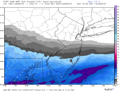
Image Courtesy WeatherBell Analytics.
Send weather related photos or videos to edgeweather2@gmail.com
Send weather related photos or videos to edgeweather2@gmail.com
Click here for the Edge Weather app in the Apple App Store.
Click here for the Edge Weather app in the Google Play Store.
Or search the Apple App Store or Google Play Store for Edgeweather.
Or search the Apple App Store or Google Play Store for Edgeweather.
Follow this blog @TheEdgeWeather on Twitter or on Facebook at TheEdgeWeather.
Also, you can access this blog at the following web addresses: edgeweather.com, theedgeweather.com, edgeweather.net, theedgeweather.net, edgeweather.us, theedgeweather.us, edgeweather.org and theedgeweather.org


No comments:
Post a Comment
Note: Only a member of this blog may post a comment.