
There will be a chance of a shower or thunderstorm this evening as a cold front passes through our area and then tomorrow will be variably cloudy with a chance of a shower in southern sections of Central NJ as a disturbance rides along the cold front just to our south. Highs tomorrow will be in the mid 40’s to low 50’s.
Sunday will then be mostly sunny with highs in the low to mid 40’s.
Monday morning a disturbance will approach from the west, developing into a Nor’easter off the NJ Coast Monday night. Snow will likely fall in Northeastern PA and Orange County, NY, with a mixture of rain and snow in East Central PA and Northern NJ, with snow more likely in Northwestern NJ and more of a mixture in Northeastern NJ, and a mixture in the rest of Southeastern NY state and Fairfield County, CT. There will also likely be a bit of snow at the start in northern portions of Central NJ, NYC, and on Long Island. Snowfall accumulations could be significant in parts of East Central and Northeastern PA (especially Northeastern PA), Northern NJ (especially Northwestern NJ), in Southeastern NY State, especially in Orange County, and in Fairfield County, CT (especially northern sections). Highs will range from the low to mid 30’s in Northeastern PA to the low to mid 40’s in Central NJ and on Long Island. Highs will range from the upper 30’s to low 40’s in Northeastern PA to the mid 50’s to low 60’s in Central NJ.
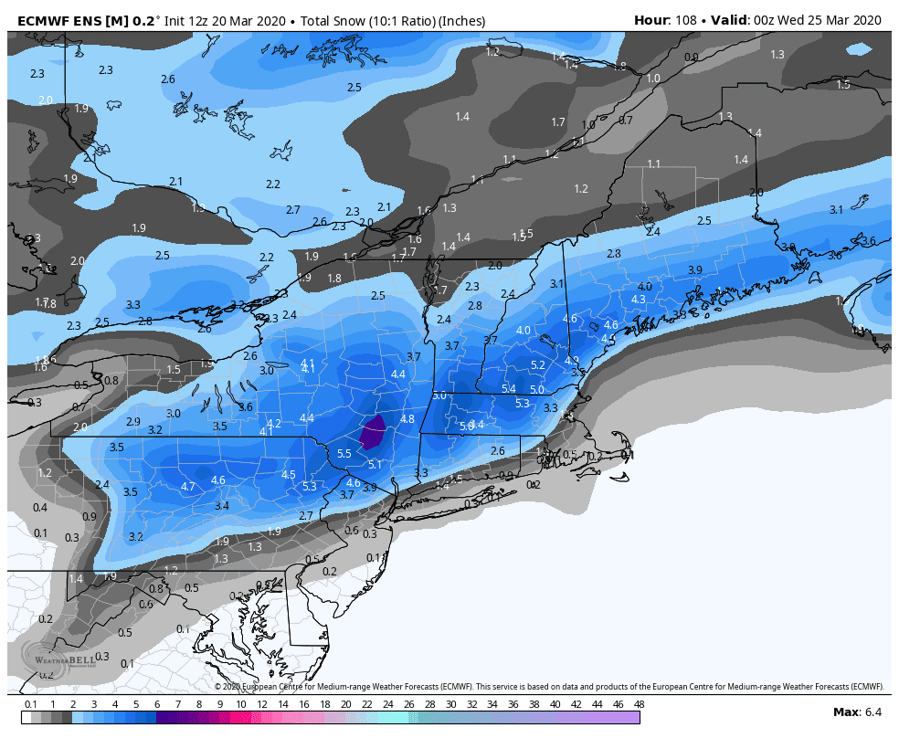
Below is the latest snowfall map from the European model ensemble mean (an averaging of the European model run 50 different ways for various conditions). Courtesy WeatherBell Analytics. Click on the image to enlarge.
And below is the latest snowfall map from the operational run of the European model, courtesy WeatherBell Analytics. Click on the image to enlarge.


And below is the latest snowfall map from the short-range American model, courtesy WeatherBell Analytics. Click on the image to enlarge.

In all honesty, I am still skeptical as it seems that none of these storms have worked out this year for the people who are hoping for some snow, but we will see what happens.
Tuesday will then be nice with highs in the mid 40’s to mid 50’s.
Wednesday there will be a chance of rain as another disturbance passes through our area. Highs will be in the 40’s.
Thursday will be variably cloudy with highs in the 50’s.
Next Friday, March 27th, there will be a chance of showers as a cold front passes through our area. Highs will be in the 50’s.
Next Saturday, March 28th, there will be a chance of rain as a disturbance passes through our area. Highs will be in the upper 40’s to mid 50’s.
Next Sunday, March 29th, and next Monday, March 30th, are then looking nice with highs in the 50’s.
Next Tuesday, March 31st, and next Wednesday, April 1st, will be variably cloudy with a chance of a shower as a disturbance passes through our area. Highs will be in the mid 50’s to low 60’s next Tuesday and the 50’s next Wednesday.
Next Thursday, April 2nd, is then looking variably cloudy with highs in the mid 50’s to low 60’s.
Have a wonderful evening!
If you are thinking about buying or selling a home, I am a licensed real estate broker in NJ and I would be happy to assist you. Please contact me at edgeweather2@gmail.com
Send weather related photos or videos to edgeweather2@gmail.com
Click here for the Edge Weather app in the Apple App Store.
Click here for the Edge Weather app in the Google Play Store.
Or search the Apple App Store or Google Play Store for Edgeweather.
Or search the Apple App Store or Google Play Store for Edgeweather.
Follow this blog @TheEdgeWeather on Twitter or Facebook.
Also, you can access this blog at the following web addresses: edgeweather.com, theedgeweather.com, edgeweather.net, theedgeweather.net, edgeweather.us, theedgeweather.us, edgeweather.org and theedgeweather.org
Also, you can access this blog at the following web addresses: edgeweather.com, theedgeweather.com, edgeweather.net, theedgeweather.net, edgeweather.us, theedgeweather.us, edgeweather.org and theedgeweather.org
No comments:
Post a Comment
Note: Only a member of this blog may post a comment.