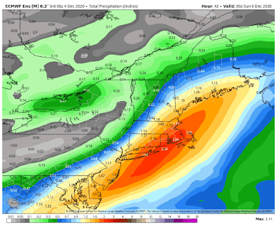
A Nor’easter will bring heavy rain, strong wind, and even some snow to parts of our area tonight into tomorrow morning and then a cold Sunday ahead…
Below is the latest total rainfall map from the European model ensemble mean, courtesy WeatherBell Analytics.
And below is the latest total snowfall map from the European model ensemble mean, courtesy WeatherBell Analytics.
And below is the latest total precipitation map from the operational run of the European model courtesy WeatherBell Analytics...
And below is the latest total snowfall map from the operational run of the European model, courtesy WeatherBell Analytics...
Disturbances in the northern and southern jet streams will combine to bring much of our area heavy rain, strong wind, and even some snow to parts of our area tonight into tomorrow…
Clouds will increase today as the two disturbance approach our area, with rain developing in the late morning and afternoon from south to north. It will also become windy as the two disturbances start to merge, forming a Nor’easter. Highs will be in the mid 40’s to low 50’s.
Tomorrow, there will be rain, heavy at times in East Central NJ and on Long Island, ending in the afternoon and evening from west to east. The rain could mix with or change to snow before ending in Fairfield County, CT. It will also be windy, with gusts up to 40 mph inland and up to 50 mph along the coast and on Long Island. Highs will be in the upper 30’s to mid 40’s.
Sunday will be variably cloudy with a chance of a snow shower or flurry in Northeastern PA. Highs will be in the upper 20’s and 30’s.
Monday through next Sunday, December 13th, are then looking nice with highs gradually rising from the 30’s Monday and Tuesday, to the mid 30’s to low 40’s Wednesday, the low to mid 40’s Thursday, and the 40’s next Friday, then dropping back to the upper 30’s to mid 40’s next Saturday and the mid 30’s to mid 40’s next Sunday.
Next Monday, December 14th, clouds will increase with a chance of rain or snow developing at night as a disturbance approaches our area. Highs will be in the upper 30’s to mid 40’s.
Next Tuesday, December 15th, there will be a chance of rain or snow with highs in the mid 30’s to mid 40’s.
Send weather related photos or videos to edgeweather2@gmail.com
Follow this blog @TheEdgeWeather on Twitter or Facebook.
Also, you can access this blog at the following web addresses: edgeweather.com, theedgeweather.com, edgeweather.net, theedgeweather.net, edgeweather.us, theedgeweather.us, edgeweather.org and theedgeweather.org
Follow this blog @TheEdgeWeather on Twitter or Facebook.
Also, you can access this blog at the following web addresses: edgeweather.com, theedgeweather.com, edgeweather.net, theedgeweather.net, edgeweather.us, theedgeweather.us, edgeweather.org and theedgeweather.org


No comments:
Post a Comment
Note: Only a member of this blog may post a comment.