
More snow in at least parts of our area tomorrow and another chance Thursday into Friday morning…
Today will be mostly sunny with highs in the low to mid 20’s.
Tomorrow a disturbance will approach our area, bringing a chance of a snow to our area. There will however be a very fine line between who gets snow and who doesn’t, depending on the exact track of the disturbance. Places to the south of the track of the disturbance will receive little if any snow, while places just to the north of the track of the disturbance will likely receive a significant snowfall with 2-8 inches likely. Right now that appears to be Northeastern PA, Northwestern NJ, Southeastern NY State, and Fairfield County, CT, with a slight chance further south. The snow will start between about 4 and 7 am from west to east, ending in the evening. Highs will be in the mid 20’s to mid 30’s.
Total possible accumulations:
A trace to 2 inches with a slight chance of higher accumulations: Central NJ, NYC, and Long Island
2-8 inches likely: East Central and Northeastern PA, Northern NJ, Southeastern NY State, and Fairfield County, CT
Below is the latest medium-range American model snowfall map, courtesy WeatherBell Analytics. Click on the image to enlarge.


Below is the latest short-range Canadian model snowfall map, courtesy WeatherBell Analytics. Click on the image to enlarge.

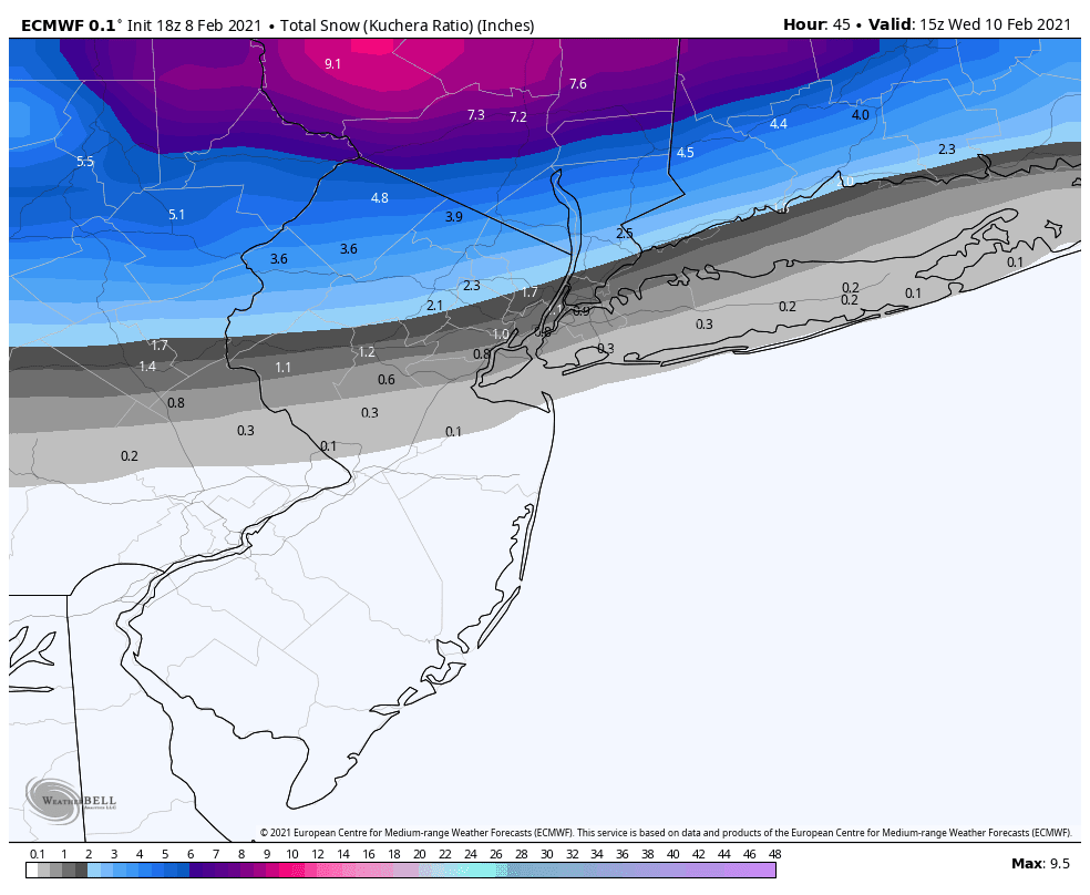
Below is the latest European model snowfall map, courtesy WeatherBell Analytics. Click on the image to enlarge.
Wednesday will be variably cloudy with a chance of snow developing at night from southwest to northeast as another disturbance approaches our area. Highs will be in the mid 20’s to low 30’s.
Thursday there will be a chance of snow, especially in Central NJ, as a disturbance passes by our area. Highs will be in the low to mid 20’s.
Friday there will be a chance of snow ending in the morning as the disturbance departs our area. Highs will be in the upper teens to mid 20’s.
Saturday will be variably cloudy with a chance of snow developing at night as another disturbance approaches our area. Highs will be in the upper teens to mid 20’s.
Sunday there will be a chance of snow ending early in the morning, followed by clearing. Highs will be in the mid teens to mid 20’s.
Next Monday, February 15th, will be mostly sunny with highs in the upper teens to mid 20’s.
Next Tuesday, February 16th, clouds will increase with a chance of snow developing at night as another disturbance approaches our area. Highs will be in the mid 20’s to low 30’s.
Next Wednesday, February 17th, there will be a chance of rain or snow as a disturbance passes by our area. Highs will be in the 30’s.
Next Thursday, February 18th, there will be a chance of rain or snow ending in the morning. Highs will be in the 30’s.
Next Friday, February 19th and next Saturday, February 20th, will be variably cloudy with highs in the low to mid 30’s next Friday and the 30’s next Saturday.
Next Sunday, February 20th, there will be a chance of rain or snow. Highs will be in the mid 30’s to low 40’s.
No comments:
Post a Comment
Note: Only a member of this blog may post a comment.