An inch or two of snow likely tomorrow morning in most places and then watching Saturday closely…
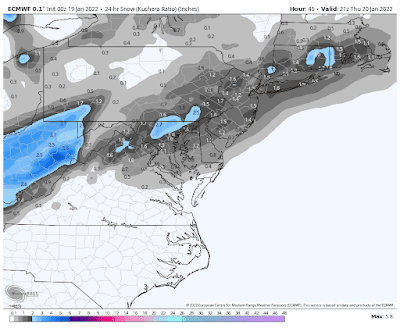
A cold front will be passing through our area tomorrow, with a weak disturbance riding along this front. This will cause snow to develop tomorrow morning, just in time for the morning rush hour and ending in the afternoon in most parts of our area with an inch or two of accumulation likely in most places.
Below is the latest snow map for tomorrow from the European model, courtesy WeatherBell Analytics. Click on the image to enlarge.
Then of significant interest will be a Nor’easter that is likely to develop near the Middle Atlantic Coast Friday night into Saturday morning. At the moment, the most likely scenario is that the storm will remain far enough off the coast to keep most of our area free of snow, except possibly parts of Southern NJ, the NJ Coast, and Eastern Long Island. However, as you will see below, the European ensemble members show a wide range of possible solutions from a blizzard to a dry day for most of our area, so we definitely need to monitor this situation closely.
Below are the 50 ensemble members from the European model, as well as the operational run of the European model for Friday morning into Saturday.
Have a fantastic day!
Send weather related photos or videos to edgeweather2@gmail.com
Follow this blog @TheEdgeWeather on Twitter
Also, you can access this blog at the following web addresses: edgeweather.com, theedgeweather.com, edgeweather.net, theedgeweather.net, edgeweather.us, theedgeweather.us, edgeweather.org, theedgeweather.org, and theedgeweather.blogspot.com


No comments:
Post a Comment
Note: Only a member of this blog may post a comment.