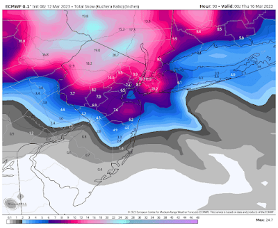
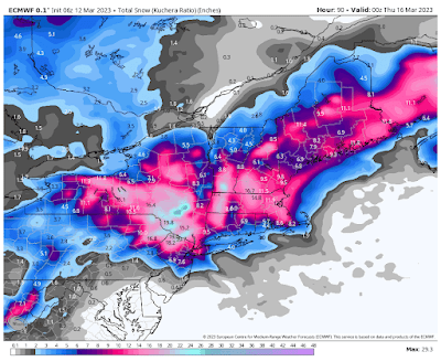
A strong Nor’easter will develop off the Middle Atlantic Coast tomorrow and Tuesday, bringing most of our area a significant snowfall and parts of our area a very significant snowfall…
I will be updating the snow map below throughout the day as new model runs become available so please be sure to check back for updates...
Two disturbances are approaching our area and will combine off the Middle Atlantic Coast Monday, causing a strong Nor’easter to form. This Nor’easter will then move northward off the NJ Coast, pulling moisture back into our area. The precipitation will start Monday morning as snow in Northeastern PA, a mixture or rain and snow in East Central PA, Northwestern NJ, and Orange County, NY, and rain elsewhere. The rain will then gradually change to snow in the evening in East Central PA, Northwestern NJ, Rockland and Putnam Counties in NY and in Northern Fairfield County, CT, and in the very early morning hours in Central and Northeastern NJ and the rest of Fairfield County, CT, and in NYC, and then in the morning on Long Island, then end in the late afternoon and early evening. It will also become windy Tuesday morning with gusts up to 40 mph possible, especially in Southern sections and on Eastern Long Island.
Total possible snowfall accumulation:
A trace to an inch or two possible: Southeastern PA, Southern NJ
2-5 inches possible: Central and Eastern Long Island
2-8 inches possible: East Central PA from southwest to northeast, Central NJ from south to north, Long Island
5-10 inches possible: Western Long Island, Fairfield County, CT
6-12 inches possible: far western sections of Northeastern PA, southwestern sections of Northwestern NJ and Northeastern NJ, Westchester County NY, NYC
10-20 inches possible: the rest of Northeastern PA, the rest of Northwestern NJ, Orange, Rockland, and Putnam Counties in NY State
Below is the latest European model snow map, courtesy WeatherBell Analytics. Click on the image to enlarge.
After this storm passes temperatures will gradually warm to the 50’s by Friday with a chance of showers Friday night into Saturday morning as a cold front approaches and then passes through area.
The next chance for rain or snow will then be Next Wednesday and Thursday as another disturbance passes through our area.


No comments:
Post a Comment
Note: Only a member of this blog may post a comment.