Rain ending this afternoon and then watching a potential Nor’easter for Wednesday night into Thursday…
The rain will end this afternoon with highs reaching the upper 50’s in East Central NJ this afternoon.
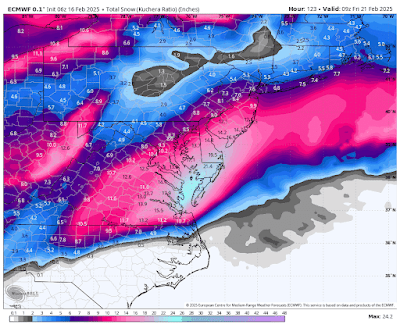
Tomorrow and Tuesday will then be nice but colder, followed by increasing cloudiness Wednesday and a chance of snow developing Wednesday night as a strong disturbance approaches from the Southeastern United States. This disturbance is likely to bring very heavy snowfall to Eastern Virginia, Southeastern Maryland, and Southern NJ. Right now it appears that our area will be on the northwest fringes of this storm with snowfall in the 4-8 range in much of our area, but being on the fringe means this can very easily go higher or lower depending on the exact track of the storm, so I am nowhere near close to giving an actual estimate at this time. We can still literally go from basically nothing to over a foot, depending on how this storm develops and the track that it takes.
Below is the latest snowfall estimate for this storm from the European model, courtesy WeatherBell Analytics. Click on the image to enlarge. PLEASE KEEP IN MIND THIS WILL CHANGE HIGHER OR LOWER AS WE GET CLOSER IN TIME, SO THIS IS JUST TO LET YOU KNOW WHAT THE MODEL IS SHOWING RIGHT NOW AND IS NOT INTENDED AS AN ACTUAL ESTIMATE FOR OUR AREA.
After this storm passes things are looking good through the following 10 days or so, with just a chance for some rain or snow showers next Thursday, February 27th.


No comments:
Post a Comment
Note: Only a member of this blog may post a comment.