
URGENT - IMMEDIATE BROADCAST REQUESTED
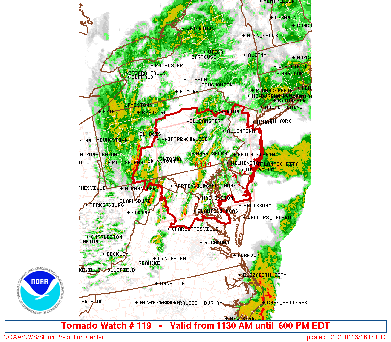
Tornado Watch Number 119
NWS Storm Prediction Center Norman OK
1130 AM EDT Mon Apr 13 2020
The NWS Storm Prediction Center has issued a
* Tornado Watch for portions of
District Of Columbia
Delaware
Maryland
New Jersey
Central and eastern Pennsylvania
Northern Virginia
Eastern West Virginia Panhandle
Coastal Waters
* Effective this Monday morning and evening from 1130 AM until
600 PM EDT.
* Primary threats include...
A couple tornadoes possible
Scattered damaging wind gusts to 70 mph likely
Isolated large hail events to 1.5 inches in diameter possible
SUMMARY...Clusters of strong to severe thunderstorms will likely
develop rapidly northeast across the Mid-Atlantic region this
afternoon. Scattered damaging winds are likely and a couple tornadic
storms will be possible.
The tornado watch area is approximately along and 100 statute miles
east and west of a line from 55 miles northwest of Allentown PA to
35 miles south southeast of Washington DC. For a complete depiction
of the watch see the associated watch outline update (WOUS64 KWNS
WOU9).
PRECAUTIONARY/PREPAREDNESS ACTIONS...
REMEMBER...A Tornado Watch means conditions are favorable for
tornadoes and severe thunderstorms in and close to the watch
area. Persons in these areas should be on the lookout for
threatening weather conditions and listen for later statements
and possible warnings.
&&
OTHER WATCH INFORMATION...CONTINUE...WW 118...
AVIATION...Tornadoes and a few severe thunderstorms with hail
surface and aloft to 1.5 inches. Extreme turbulence and surface wind
gusts to 60 knots. A few cumulonimbi with maximum tops to 400. Mean
storm motion vector 23045.
...Grams
======================================================================
371
WWUS40 KWNS 131529
WWP9
TORNADO WATCH PROBABILITIES FOR WT 0119
NWS STORM PREDICTION CENTER NORMAN OK
1027 AM CDT MON APR 13 2020
WT 0119
PROBABILITY TABLE:
PROB OF 2 OR MORE TORNADOES : 40%
PROB OF 1 OR MORE STRONG /EF2-EF5/ TORNADOES : 20%
PROB OF 10 OR MORE SEVERE WIND EVENTS : 60%
PROB OF 1 OR MORE WIND EVENTS >= 65 KNOTS : 20%
PROB OF 10 OR MORE SEVERE HAIL EVENTS : 20%
PROB OF 1 OR MORE HAIL EVENTS >= 2 INCHES : 10%
PROB OF 6 OR MORE COMBINED SEVERE HAIL/WIND EVENTS : 80%
&&
ATTRIBUTE TABLE:
MAX HAIL /INCHES/ : 1.5
MAX WIND GUSTS SURFACE /KNOTS/ : 60
MAX TOPS /X 100 FEET/ : 400
MEAN STORM MOTION VECTOR /DEGREES AND KNOTS/ : 23045
PARTICULARLY DANGEROUS SITUATION : NO
&&
FOR A COMPLETE GEOGRAPHICAL DEPICTION OF THE WATCH AND
WATCH EXPIRATION INFORMATION SEE WOUS64 FOR WOU9.
$$
Please Be Smart, Listen to the Warnings, and Do Your Best to Keep Yourself and Your Family Healthy…
If you are thinking about buying or selling a home, I am a licensed real estate broker in NJ and I would be happy to assist you. Please contact me at edgeweather2@gmail.com
Send weather related photos or videos to edgeweather2@gmail.com
Click here for the Edge Weather app in the Apple App Store.
Click here for the Edge Weather app in the Google Play Store.
Or search the Apple App Store or Google Play Store for Edgeweather.
Or search the Apple App Store or Google Play Store for Edgeweather.
Follow this blog @TheEdgeWeather on Twitter or Facebook.
Also, you can access this blog at the following web addresses: edgeweather.com, theedgeweather.com, edgeweather.net, theedgeweather.net, edgeweather.us, theedgeweather.us, edgeweather.org and theedgeweather.org
Also, you can access this blog at the following web addresses: edgeweather.com, theedgeweather.com, edgeweather.net, theedgeweather.net, edgeweather.us, theedgeweather.us, edgeweather.org and theedgeweather.org
No comments:
Post a Comment
Note: Only a member of this blog may post a comment.