
Isaias to affect our area Monday afternoon through Wednesday morning, bringing heavy rain and flooding to our area…
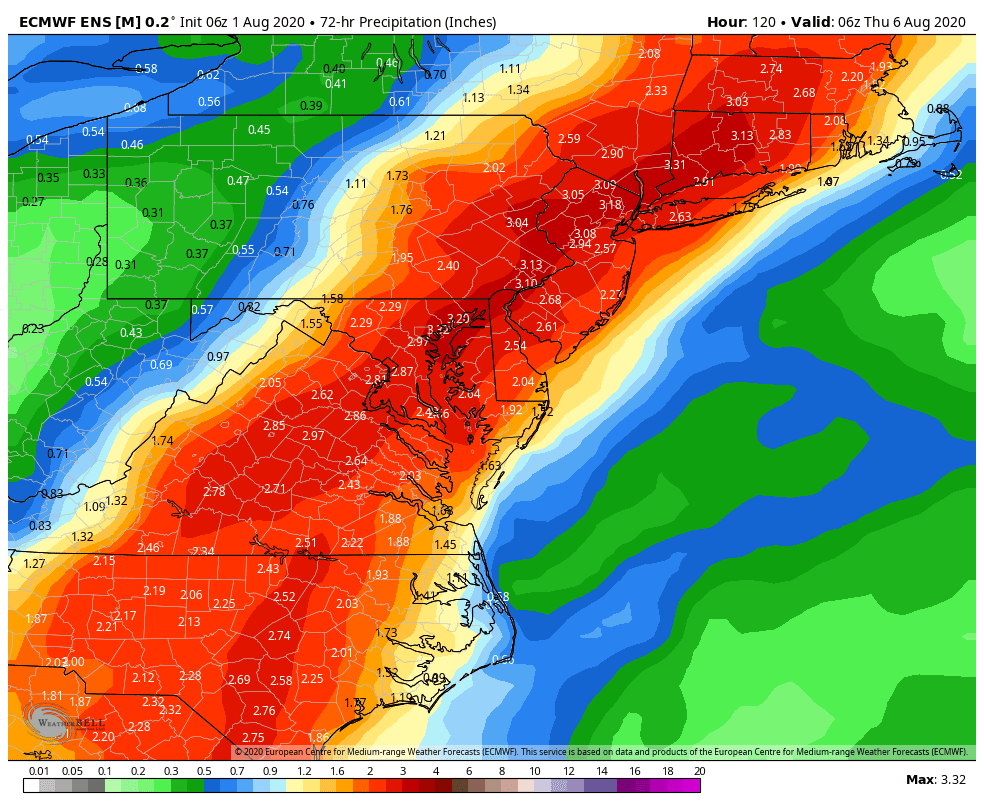
Hurricane Isaias is currently passing through the Bahamas and will reach the Central Florida East Coast tomorrow night, possibly making landfall and then turning north, likely making landfall again early Tuesday along the Central South Carolina Coast. Isaias will then turn northeastward, likely passing through our area late Tuesday into early Wednesday, bringing some heavy rain to our area that could cause some flooding, along with gusty winds along the coast and on Eastern Long Island. Total rainfall amounts are currently looking like 1-3 inches, with locally higher amounts, possibly up to 6 inches. Click here for the latest on Hurricane Isaias from the National Hurricane Center. And below is the latest potential rainfall map from the European Model Ensemble Mean, courtesy Weather Bell Analytics. Click on the map to enlarge.
Today will be variably cloudy with highs in the mid 80’s to low 90’s.
Tomorrow will be variably cloudy with a chance of showers or thunderstorms. Some of the storms could be severe, as a strong disturbance passes to our north. Click here for the latest Convective Outlook from the National Weather Service Storm Predication Center. Highs will be in the mid 80’s to low 90’s.
Monday, clouds will increase with showers or thunderstorms developing in the afternoon and evening from south to north as Hurricane Isaias moves northward along the coast of the Southeastern United States. Highs will be in the 80’s.
Tuesday, showers, or thunderstorms will be likely, possibly heavy at times, with some flooding possible, as Isaias moves northeastward through the Eastern Carolinas, Southeastern Virginia, across the Delmarva, and then through our area late at night. It will also become windy along the coast and on Eastern Long Island, with gusts of up to 45 mph possible in the afternoon and at night. Some flooding will be likely in our area. Highs will be in the 70’s.
Wednesday, showers, or thunderstorms will end in the morning, followed by clearing, as Isaias continues moving northeastward, departing our area. Some flooding will be likely, with total rainfall amounts of 1-3 inches likely, and possibly up to 6 inches in some places. Highs will be in the mid 70’s to mid 80’s.
Thursday and Friday are then looking nice with highs in the mid 70’s to low 80’s Thursday, rising to the upper 70’s to mid 80’s Friday.
Next Saturday, August 8th, will be variably cloudy with a slight chance of a shower or thunderstorm. Highs will be in the upper 70’s to mid 80’s.
Next Sunday, August 9th, will be mostly cloudy with a chance of showers or thunderstorms as a disturbance approaches from the west, possibly developing into a coastal storm near the Middle Atlantic Coast. Highs will be in the upper 70’s to mid 80’s.
Next Monday, August 10th, will be variably cloudy with a chance of a shower or thunderstorm as the disturbance departs our area. Highs will be in the upper 70’s to low 80’s.
Next Tuesday, August 11th, through next Friday, August 14th, are then looking variably cloudy with highs in the upper 70’s to mid 80’s next Tuesday through Thursday, and in the low to mid 80’s next Friday, August 14th.
Stay Healthy...
Follow this blog @TheEdgeWeather on Twitter or Facebook.
Also, you can access this blog at the following web addresses: edgeweather.com, theedgeweather.com, edgeweather.net, theedgeweather.net, edgeweather.us, theedgeweather.us, edgeweather.org and theedgeweather.org
If you are thinking about buying or selling a home, I am a licensed real estate broker in NJ and I would be happy to assist you. Please contact me at edgeweather2@gmail.com
Send weather related photos or videos to edgeweather2@gmail.com
Click here for the Edge Weather app in the Apple App Store.
Click here for the Edge Weather app in the Google Play Store.
Or search the Apple App Store or Google Play Store for Edgeweather.
Or search the Apple App Store or Google Play Store for Edgeweather.
Follow this blog @TheEdgeWeather on Twitter or Facebook.
Also, you can access this blog at the following web addresses: edgeweather.com, theedgeweather.com, edgeweather.net, theedgeweather.net, edgeweather.us, theedgeweather.us, edgeweather.org and theedgeweather.org
Also, you can access this blog at the following web addresses: edgeweather.com, theedgeweather.com, edgeweather.net, theedgeweather.net, edgeweather.us, theedgeweather.us, edgeweather.org and theedgeweather.org
No comments:
Post a Comment
Note: Only a member of this blog may post a comment.