Hurricane Henri is approaching and is likely to cause flooding in parts of our area, possibly severe flooding in some places, and strong winds may cause damage on Long Island. Model maps posted...
Henri has reached Hurricane strength and is approaching from the south. Henri will make landfall on Eastern Long Island around midday tomorrow and then will track north, northwestward, through Western Connecticut and into Southeastern NY State by tomorrow night, and then will finally move eastward through Massachusetts Monday. This track will bring parts of our area very heavy rainfall and strong winds. Click here for the latest on Hurricane Henri from the National Hurricane Center…
Below is the latest European Ensemble mean total precipitation map courtesy WeatherBell Analytics. Click on the image to enlarge…
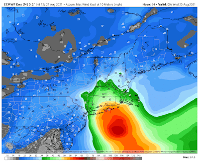
Below is the maximum wind gust map from the European model, courtesy WeatherBell Analytics. Click on the image to enlarge…
Below is the latest total precipitation map from the operational run of the European model, courtesy WeatherBell Analytics. Click on the image to enlarge…
Below is the latest maximum wind gust map from the operational run of the European model, courtesy WeatherBell Analytics. Click on the image to enlarge…
There will be a chance of a shower or thunderstorm this afternoon and then rain will develop at night from south to north as Henri approaches from the south. Highs will be in the upper 70’s to mid 80’s.
Tomorrow rain will be likely, possibly heavy at times at night, becoming windy in Fairfield County, CT and on Eastern Long Island, with gusts of 40-60 mph possible in Fairfield County, Ct and on Central Long Island , and 50-70 mph on Eastern Long Island. Highs will be in the mid to upper 70’s.
Monday, rain will be likely, possibly heavy at times during the day, then ending from west to east at night. It will be windy with gusts up to 40 mph possible. Highs will be in the mid 70’s to mid 80’s.
Total rainfall amounts will be as follows:
Eastern PA – .5 to 1.5 inches from west to east
Southern NJ – 1 to 2 inches from west to east
Central NJ – 1.5 to 3 inches from west to east
Northwestern NJ – 1 to 3 inches from west to east
Northeastern NJ – 2.5 to 4.5 inches from southwest to northeast
NYC – 2.5 to 4.5 inches from southwest to northeast
Long Island – 2-7 inches with highest amounts likely in Central Long Island and lowest amounts possible on far Eastern Long Island. Amounts over 7 inches possible on Central Long Island
Southeastern NY State – 2 to 7 inches possible west to east, with some higher amounts possible in Westchester and Putnam Counties
Tuesday and Wednesday will then be nice with highs in the mid to upper 80’s Tuesday and the mid 80’s to low 90’s Wednesday.
Thursday will be variably cloudy with a chance of an afternoon or evening shower or thunderstorm. Highs will be in the 80’s.
Friday through next Sunday, August 29th, are then looking variably cloudy with a slight chance of an afternoon or evening shower or thunderstorm. Highs will be in the upper 70’s to mid 80’s Friday, the mid 70’s Saturday, and the mid 70’s to low 80’s next Sunday.
Next Monday, August 30th, is looking nice with highs in the upper 70’s to mid 80’s.
Next Tuesday, August 31st, will be variably cloudy with a chance of an afternoon or evening shower or thunderstorm. Highs will be in the upper 70’s to mid 90’s.
Next Wednesday, September 1st, through next Friday, September 3rd, are then looking nice with highs in the mid 70’s to low 80’s next Wednesday, the mid 70’s to mid 80’s next Thursday, and the mid 70’s to low 80’s next Friday.


No comments:
Post a Comment
Note: Only a member of this blog may post a comment.