Snow, ice, flooding rain, and strong wind tonight into tomorrow…
A strong disturbance will be passing through our area tonight into tomorrow morning, bringing snow, ice, and heavy flooding rain to our tonight into tomorrow morning. The snow will be significant in Northeastern PA and far Northwestern Orange County, NY, with flooding rain likely after some snow in Northeastern NJ, and it will be windy throughout our area with gusts up to 50 mph inland, up to 60 mph along the NJ Coast, and up to 75 mph on Long Island.
The rain will change back to snow throughout our area tomorrow morning, with another inch or two of snowfall possible before ending in the afternoon or early evening as the disturbance departs our area.
Total possible snowfall accumulation this evening:
A Trace to a coating possible: Far Southeastern PA (Philadelphia area), Southern NJ and Long Island
Coating to an inch possible: Philadelphia Suburbs, Central and far Northeastern NJ, NYC, Southern Westchester County, NY, and Coastal Fairfield County, CT
1-3 inches possible: the rest of Southeastern PA, East Central PA, Northwestern NJ except far Northwestern NJ, the rest of Southeastern NY State, except far Northwestern Orange County, NY, and inland Fairfield County, CT
3-6 inches with locally higher amounts possible: far Northwestern NJ
4-12 inches: Northeastern PA and far Northwestern Orange County, NY
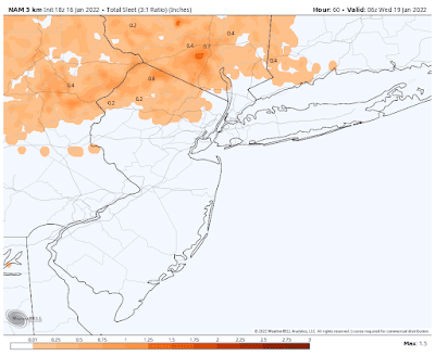
Below are the latest snow, sleet, freezing rain, and rain maps from the latest short-range American model, courtesy WeatherBell Analytics. Click on the images to enlarge…


No comments:
Post a Comment
Note: Only a member of this blog may post a comment.